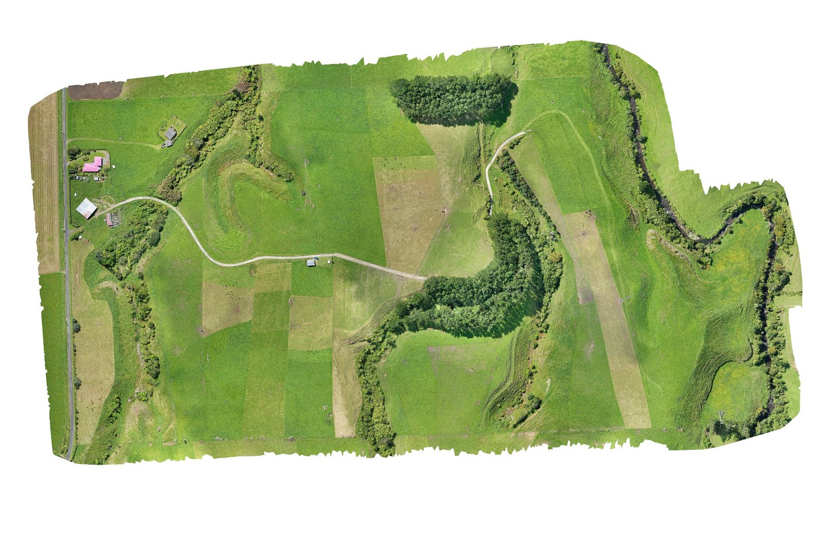
What we do

Services

GeoMap NZ provides practical drone mapping services for land, projects, monitoring, and site understanding. Whether you need a high-resolution orthomosaic, a 3D model, multispectral data, GIS layers, or help measuring and understanding a site, the focus is on useful outputs that suit the job.

Orthomosaics

Orthomosaics are high-resolution aerial maps built from lots of overlapping drone photos stitched into one detailed image. They give you a proper top-down view of a site, so you can clearly see things like fences, drainage, tracks, buildings, crop rows, waterways, vegetation and terrain.

Ground sampling distance, or GSD, describes how much ground each pixel represents in the final image. A lower GSD means a sharper and more detailed orthomosaic. Depending on the flight height, camera, site conditions and required output, drone imagery can often be much sharper than general online map imagery.

Orthomosaic example

3D Models

We can build georeferenced 3D models that allow you to look around a site, understand the land, and take useful measurements. The level of detail can be matched to the project, from simple site visualisation through to higher-resolution models where more detail is needed.

These models can be exported in different formats for CAD, GIS, design work, planning, and other project uses. They can also be textured in different ways depending on what is most useful for the client. For some projects, we can also look at newer visualisation options such as video fly-throughs or Gaussian splatting, where those outputs help show the site more clearly.

3D model example

Multispectral Mapping

Our DJI Phantom 4 Multispectral captures standard RGB imagery as well as multispectral bands that can be used to create vegetation index maps such as NDVI and similar outputs.

These maps can help show differences in vegetation, plant health, crop condition, pasture performance, moisture stress, or other patterns that may not be obvious in normal aerial photos.

Specialist interpretation

We can collect and process the imagery, then provide the maps and data outputs for farmers, landowners, agronomists, or agricultural specialists to interpret. We are not claiming to be agronomists or crop-health specialists. Our role is to collect and process the data clearly, so the right specialist can use it to make better decisions.

Multispectral mapping example

GIS Data & Layers

Tell us what you need from the map, and we can work with you to build useful GIS layers and outputs around that. This could include simple labels, boundaries, access tracks, fence lines, drains, planting areas, waterways, structures, hazards, or other site features.

We are always learning and developing our GIS skills, so we are happy to talk through what you need and work out the best way to present the information. The goal is to make the mapping useful, not overcomplicated.

Measurements

Orthomosaics and 3D models can support useful measurements, planning, and site understanding, depending on how the project is captured and controlled. Measurements can be used for distances, areas, access routes, vegetation boundaries, building positions, earthworks, and general planning.

Where stronger accuracy is required, ground control points and GNSS control can be used to improve the reliability of the final output.

Repeatable Surveys

Once a flight path has been planned and saved, it becomes much easier to repeat the same survey later. This is useful for monitoring change over time, such as vegetation growth, planting success, construction progress, earthworks, erosion, land movement, stockpiles, and general site development.

Repeatable drone surveys can help build a clear visual record of how a site changes over months or years.

Deliverables

Once all imagery has been processed and the final outputs have been built, we can provide a standard deliverables package in several practical formats. This can include GeoTIFF for georeferenced mapping, 3D PDF for viewing 3D models in compatible software such as Adobe, MBTiles as a compressed format suitable for many GPS, navigation, and mapping platforms, and a full-resolution PDF for high-quality viewing, printing, and sharing.

Need something specific?

If there is a service you would like to ask about, get in touch and we can talk it through. We are always wanting to learn new skills and broaden what GeoMap NZ can offer, while keeping the work practical and useful.